When is the Best Time to Visit the Philippines?

The Philippines basically has three seasons: Hot, Rainy and Cold. How they define Cold, to someone from the UK, is a little puzzling though ;) Cold Season: December to February Hot Season: March to May Rainy Season: June to November

The Seasons in The Philippines

The Philippines basically has three seasons: Hot, Rainy and Cold.

How they define Cold, to someone from the UK, is a little puzzling though 😉

  • Cold Season: December to February
  • Hot Season: March to May
  • Rainy Season: June to November

However, the above is not always correct, and can even vary by location in the Philippines.

For example: on the Eastern side, near Samar etc., it is normally the rain season from December to March.

The state weather bureau, PAGASA, announced on June 23 2015, that the rainy season had begun and that it may continue until September. Usually, the rainy season in the Philippines begins in late May. (Rainy season is declared with at least 5 days of rain generating a total amount of 25 millimeters (mm) of rainfall. At least 3 days must be consecutive rain days with 1 millimeter (mm) of rainfall)

Average approx monthly rainfall in the Philippines:

July : 260-275mm
August : 260-275mm
September : 260-275mm
October : 260-275mm

June : 245mm
November : 245mm

May : 170-180mm
December : 170-180mm

January : 135mm

February : 80-90mm
March : 80-90mm
April : 80-90mm

Holiday Seasons for Hotels etc., in the Philippines :

High Season (5 months: Dec–Apr)
Shoulder Season (2 months: May & Nov)
Low Season (4 months: Jun–Sep)

Not sure where October went from the above list 😉

Typhoon Season in the Philippines

The typhoon season is normally July to October

Climate of the Philippines at PAGASA

http://www.pagasa.dost.gov.ph/index.php/climate-of-the-philippines

Earthquakes in Philippines April 2015

Philippine Earthquakes in April 2015

Source: http://www.phivolcs.dost.gov.ph

Date – Time                                 Latitude  Longitude   Depth  Magnitude      Location
(Philippine Time)                               (ºN)         (ºE)           (km)

30 Apr 2015 – 02:53 PM         10.73     121.66       047      2.6  031 km S 87° W of San Jose (Antique)

30 Apr 2015 – 12:18 PM         13.18     120.04       022      3.8  053 km S 61° W of Paluan (Occidental Mindorol)

29 Apr 2015 – 04:27 PM         10.17     123.14       025      2.9  015 km N 71° W of Guihulngan (Negros Oriental)

29 Apr 2015 – 02:15 PM         10.15     123.23       009      3.6  005 km N 56° W of Guihulngan (Negros Oriental)

28 Apr 2015 – 09:55 PM         13.71     120.53       028      2.3  018 km S 41° W of Calatagan (Batangas)

27 Apr 2015 – 11:48 PM         03.62     123.67       546      4.2   284 km S 45° W of Sarangani (Davao Occidental)

27 Apr 2015 – 08:04 PM         05.92     125.88       163      3.5   029 km N 82° E of Jose Abad Santos (Davao Occidental)

27 Apr 2015 – 04:21 PM         13.78     121.49       018      3.6   011 km S 61° E of San Juan (Batangas)

26 Apr 2015 – 02:14 PM         13.53     121.07       019      2.4   013 km N 77° E of Puerto Galera (Oriental Mindoro)

26 Apr 2015 – 01:51 PM         18.00     120.21       034      3.2   029 km S 68° W of Currimao (Ilocos Norte)

26 Apr 2015 – 01:22 AM         06.22     125.74       140      3.1   005 km N 68° E of Don Marcelino (Davao Occidental)

25 Apr 2015 – 10:06 PM         13.09     123.53       023      3.4   007 km N 75° W of Jovellar (Albay)

25 Apr 2015 – 08:26 PM         06.66     124.21       008      2.0   015 km N 84° E of Lebak (Sultan Kudarat)

25 Apr 2015 – 01:34 PM         08.49     125.87       001      3.7   10 km N 68° E of Talacogon (Agusan del Sur)

25 Apr 2015 – 04:41 AM         06.27     127.18       029      3.4   118 km S 43° E of Tarragona (Davao Oriental)

25 Apr 2015 – 01:38 AM         05.57     125.67       203      2.3   026 km N 55° E of Sarangani (Davao Occidental)

24 Apr 2015 – 11:39 PM         08.94     126.32       024      2.1   003 km N 36° E of Cagwait (Surigao del Sur)

24 Apr 2015 – 02:32 PM         04.68     125.88       014      2.9   095 km S 28° E of Sarangani (Davao Occidental)

24 Apr 2015 – 05:34 AM         09.42     125.75       008      3.2   048 km S 36° E of Surigao City

24 Apr 2015 – 04:22 AM         06.87     126.17       029      2.7   011 km S 29° W of Mati (Davao Oriental)

24 Apr 2015 – 03:26 AM         08.08     127.60       036      4.4   141 km S 83° E of Bislig City (Surigao del Sur)

24 Apr 2015 – 02:22 AM         05.18     125.38       187      4.0   030 km S 21° W of Sarangani (Davao del Sur)

24 Apr 2015 – 01:38 AM         06.81     125.62       033      2.2   028 km S 3° E of Davao City

23 Apr 2015 – 12:51 AM         19.76     121.56       033      2.7   053 km N 11° E of Calayan (Cagayan)

22 Apr 2015 – 09:45 PM         09.85     126.13       024      3.9   003 km S 62° E of Pilar (Surigao del Norte)

22 Apr 2015 – 01:47 AM         08.57     126.55       069      3.2   032 km N 46° E of Hinatuan (Surigao del Sur)

21 Apr 2015 – 11:22 PM         04.77     126.25       021      2.5   113 km S 50° E of Sarangani (Davao Occidental)

21 Apr 2015 – 10:19 PM         13.28     119.99       013      3.3   054 km S 74° E of Paluan (Occidental Mindoro)

21 Apr 2015 – 08:53 PM         05.94     126.08       124      2.9   051 km N 83° E of Jose Abad Santos (Davao Occidental)

21 Apr 2015 – 07:14 PM         05.93     125.37       061      3.4   009 km S 65° E of Malapatan (Sarangani)

21 Apr 2015 – 03:59 AM         10.19     124.80       023      3.3   007 km N 30° W of Maasin (Southern Leyte)

20 Apr 2015 – 06:31 PM         06.95     126.63       021      3.1   022 km S 61° E of Tarragona (Davao Oriental)

20 Apr 2015 – 12:50 PM         06.92     126.92       190      2.5   053 km S 52° E of Manay (Davao Oriental)

20 Apr 2015 – 12:18 PM         13.78     120.69       021      1.6   008 km S 48° E of Calatagan (Batangas)

20 Apr 2015 – 10:24 AM         13.82     120.46       174      2.0   019 km S 85° W of Calatagan (Batangas)

20 Apr 2015 – 04:41 AM         09.13     126.77       032      3.5   056 km N 72° E of Bayabas  (Surigao Del Sur)

19 Apr 2015 – 11:27 PM         10.03     125.88       117      2.6   016 km N 61° W of San Benito  (Surigao Del Norte)

19 Apr 2015 – 10:25 PM         13.65     120.65       048      3.5   020 km S 4° E of Calatagan  (Batangas)

19 Apr 2015 – 10:19 PM         08.96     126.13       109      3.2   010 km N 81° E of San Miguel  (Surigao Del Sur)

19 Apr 2015 – 09:20 PM        14.91      121.98       016      2.8   007 km N 14° E of Burdeos (Quezon)

19 Apr 2015 – 10:49 AM        09.78      123.90       007      2.9   06 km N 20° E of Cortes (Bohol)

19 Apr 2015 – 04:42 AM        06.52      125.99       150      2.8   017 km S 34° W of Governor Generoso (Davao Oriental)

18 Apr 2015 – 08:42 PM        11.13      124.50       028      2.6   003 km S 60° E of Matag-ob (Leyte)

18 Apr 2015 – 07:38 PM        12.28      123.48       007      3.4   018 km S 59° W of Masbate (Masbate)

18 Apr 2015 – 07:25 PM        10.62      125.63       032      2.7   029 km N 11° E of Loreto (Dinagat)

18 Apr 2015 – 07:30 AM        11.10      126.23       033      3.4   056 km N 83° E of Guiuan (Eastern Samar)

18 Apr 2015 – 04:42 AM        13.82      120.54       075      2.3   010 km S 80° W of Calatagan (Batangas)

17 Apr 2015 – 11:40 PM        10.79      125.50       177      2.8   036 km S 42° W of Guiuan (Eastern Samar)

17 Apr 2015 – 03:04 PM        10.57      126.13       024      3.7   061 km N 06° E of Burgos (Surigao Del Norte)

17 Apr 2015 – 12:14 PM        06.12      126.38       024      2.8   068 km S 30° E of Governor Generoso (Davao Oriental)

17 Apr 2015 – 09:32 AM        06.62      125.78       089      2.2   029 km N 38° E of Malita (Davao Occidental)

16 Apr 2015 – 09:29 PM        13.76      121.63       001      3.1   019 km S 7° E of Lucena City (Quezon)

16 Apr 2015 – 06:05 PM        16.54      120.65       022      3.8   016 km N 20° E of Baguio City

16 Apr 2015 – 07:27 AM        05:58      125.83       095      2.3   040 km S 35° E of Jose Abad Santos (Davao Occidental)

16 Apr 2015 – 05;37 AM        08.49      122.64       014      3.6   041 km N 04° W of Liloy (Zamboanga Del Norte)

16 Apr 2015 – 03:29 AM        06.65      123.70       031      2.7   040 km N 78° W of Kalamansig (Sultan Kudarat)

15 Apr 2015 – 09:19 PM        13.55      120.07       029      3.2   027 km S 47° W of Looc (Occidental Mindoro)

15 Apr 2015 – 08:54 PM        09.92      126.17       021      3.3   008 km S 78° E of San Isidro (Surigao del Norte)

15 Apr 2015 – 10:19 AM        07.80      124.86       001      2.9   006 km S 52° E of Pangantucan (Bukidnon)

15 Apr 2015 – 07:41 AM        05.01      127.65       024      3.1   245 km S 79° E of Sarangani (Davao Occidental)

15 Apr 2015 – 12:27 AM        12.56      125.71       015      3.1   047 km N 28° E of San Policarpo (Eastern Samar)

15 Apr 2015 – 12:15 AM        12.73      125.69       023      3.9   055 km N 59° E of Mapanas (Northern Samar)

14 Apr 2015 – 11:36 PM        14.12      119.58       107      3.1   067 km N 64° W of Lubang (Occidental Mindoro)

14 Apr 2015 – 11:35 PM        10.98      124.51       005      3.3   008 km N 17° W of Merida (Leyte)

14 Apr 2015 – 09:15 PM        05.74      126.39       114      2.4   088 km S 79° E of Jose Abad Santos(Trinidad)(Davao del Sur)

14 Apr 2015 – 09:04 PM        19.15      121.19       087      4.3   033 km S 65° W of Calayan (Cagayan)

14 Apr 2015 – 07:55 AM        16.53      120.70       011      3.5   018 km N 41° E of Baguio City

14 Apr 2015 – 04:48 AM        08.45      126.23       003      2.3   007 km S 78° E of Tagbina (Surigao del Sur)

13 Apr 2015 – 07:49 PM        03.50      126.89       012      4.2   266 km S 36° E of Sarangani (Davao Occidental)

13 Apr 2015 – 06:43 PM        16.23      120.58       033      2.8   010 km S 88° E of Rosario (La Union)

13 Apr 2015 – 04:24 PM        09.71      125.37       025      2.3   009 km S 37° W  of San Francisco (Anao-aon)(Surigao del Norte)

13 Apr 2015 – 02:49 AM        06.33      126.56       059      4.3   064 km S 56° E  of Governor Generoso (Davao Oriental)

12 Apr 2015 – 08:40 PM        07.83      124.75       013      3.2   007 km S 78° W of Pangantucan (Bukidnon)

12 Apr 2015 – 06:36 PM        09.55      126.81       002      3.2   074 km N 66° E  of Cortes (Surigao del Sur)

12 Apr 2015 – 06:15 PM        15.13      121.67       005      3.3   025 km N 37° W  of Panukulan (Quezon)

12 Apr 2015 – 03:16 PM        15.05      121.93       008      3.6   019 km N 48° E  of Panukulan (Quezon)

12 Apr 2015 – 04:04 AM        05.54      126.40       068      3.3   095 km S 66° E  of Jose Abad Santos  (Davao Occidental)

12 Apr 2015 – 12:28 AM        12.86      126.03       038      3.6   095 km N 38° E  of San Policarpio  (Eastern Samar)

11 Apr 2015 – 07:42 PM        04.45      124.97       277      4.0   122 km S 27° W of Sarangani (Davao Occidental)

11 Apr 2015 – 03:48 PM        13.71      120.84       013      2.6   006 km N 34° W of Tingloy (Batangas)

11 Apr 2015 – 03:02 AM        08.27      123.43       015      3.5   013 km N 62° W of Josefina (Zamboanga Del Sur)

10 Apr 2015 – 10:04 PM        14.07      120.46       109      3.1   018 km S 85° W of Nasugbu (Batangas)

10 Apr 2015 – 07:52 PM        12.99      125.06       032      3.3   046 km N 6° E of Laoang (Northern Samar)

10 Apr 2015 – 05:52 PM        10.92      125.47       016      3.8   022 km S 24° E of Balangiga (Eastern Samar)

10 Apr 2015 – 11:24 AM        05.18      126.16       065      3.5   081 km S 70° E of Sarangani (Davao Occidental)
10 Apr 2015 – 01:30 AM        08.64      121.90       033      2.7   093 km N 48° W of Labason (Zamboanga Del Norte)

09 Apr 2015 – 09:00 PM        15.76      120.96       001      4.0   005 km S 38° W of San Jose City (Nueva Ecija)
09 Apr 2015 – 11:49 AM        13.72      120.67       110      3.1   013 km S 19° E of Calatagan (Batangas)

09 Apr 2015 – 05:22 AM        11.35      124.34       001      2.4   016 km S 80° W of Leyte (Leyte)
09 Apr 2015 – 02:32 AM        11.97      120.12       029      3.5   008 km S 63° W of Coron (Palawan)

08 Apr 2015 – 09:16 PM        07.33      124.97       035      2.5   038 km N 21° W of Kidapawan City

08 Apr 2015 – 08:26 PM        13.04      121.09       102      3.5   039 km S 15° W of Calapan City (Oriental Mindoro)

08 Apr 2015 – 09:37 AM        08.23      123.24       023      2.2   041 km S 15° W of Dipolog City

08 Apr 2015 – 01:37 AM        09.26      125.72       025      2.2   017 km S 88° E of Santiago (Agusan Del Norte)

08 Apr 2015 – 12:42 AM        06.47      126.25       032      2.8   027 km S 45° E of Governor Generoso (Davao Oriefntal)

07 Apr 2015 – 09:38 PM        11.06      122.12       001      2.8   006 km N 09° W of Valderrama (Antique)

07 Apr 2015 – 09:30 PM        11.07      122.19       005      2.7   010 km N 42° E of Valderrama (Antique)

07 Apr 2015 – 11:59 AM        06.51      126.30       031      3.5   029 km S 57° E of Governor Generoso (Davao Oriental)

07 Apr 2015 – 06:33 AM        14.84      122.67       005      3.6   035 km N 67° E of Jomalig (Quezon)

07 Apr 2015 – 03:39 AM        09.04      126.39       036      3.6   013 km N 59° E of Bayabas (Surigao del Sur)

07 Apr 2015 – 02:35 AM        06.51      123.54       018      2.6   058 km S 83° W of Kalamansig (Sultan Kudarat)

06 Apr 2015 – 10:22 PM        05.41      126.62       025      3.3   123 km S 65° E of Jose Abad Santos (Davao Occidental)

06 Apr 2015 – 08:31 PM        10.60      122.23       041      2.3   005 km S 1° W of Miagao (Iloilo)

06 Apr 2015 – 07:01 PM        10.19      126.04       031      2.6   019 km N 11° W of Burgos (Surigao del Norte)

06 Apr 2015 – 03:41 PM        04.52      125.90       160      4.0   111 km S 25° E of Sarangani (Davao Occidental)

06 Apr 2015 – 07:59 AM        12.38      122.00       030      2.7   003 km S 49° E of Odiongan (Romblon)

05 Apr 2015 – 03:23 PM        14.79      122.67       017      3.5   033 km N 76° E of Jomalig (Quezon)

05 Apr 2015 – 12:43 PM        13.16      122.63       021      3.1   019 km S 18° W of San Andres (Quezon)

05 Apr 2015 – 09:54 AM        13.11      121.08       026      2.4   024 km S 68° W of Victoria (Oriental Mindorol)

04 Apr 2015 – 02:41 PM        06.43      126.20       041      3.0   028 km S 28° E of Governor Generoso (Davao Oriental)

03 Apr 2015 – 11:45 PM        14.93      119.71       001      3.1   042 km S 87° W of San Antonio (Zambales)

03 Apr 2015 – 11:42 PM        14.29      120.39       156      3.0   019 km S 34° W of Mariveles (Bataan)

03 Apr 2015 – 10:29 PM        05.59      126.44       015      2.7   097 km S 71° E of Jose Abad Santos (Davao Occidental)

03 Apr 2015 – 07:13 PM        11.40      126.02       095      3.2   045 km N 79° E of Hernani (Eastern Samar)

03 Apr 2015 – 05:48 PM        05.51      126.21       082      3.6   077 km S 58° E of Jose Abad Santos (Davao Occidental)

03 Apr 2015 – 03:50 PM        13.27      124.20       003      2.5   012 km N 40° E of Rapu-rapu (Albay)

02 Apr 2015 – 08:41 PM        06.48      126.78       167      3.4   072 km S 30° E of Tarragona (Davao Oriental)

02 Apr 2015 – 02:41 PM        05.47      126.54       012      3.3   112 km S 66° E of Jose Abad Santos (Davao Occidental)

02 Apr 2015 – 11: 56 AM       19.04      121.24       076      3.6   037 km S 43° W of Calayan (Cagayan)

02 Apr 2015 – 06:20 AM        06.28      125.88       045      3.1   022 km N 66° E of Don Marcelino (Davao Occidental)

02 Apr 2015 – 12:45 AM        17.47      120.08       065      3.0   033 km S 68° W of Santa Catalina (Ilocos Sur)

01 Apr 2015 – 12:35 AM        10.43      126.07       022      2.1   045 km N 1° W of Burgos (Surigao del Norte)

01 Apr 2015 – 10:31 PM        09.16      125.70       034      1.8   017 km N 75° E of Cabadbaran (Agusan del Norte)
01 Apr 2015 – 12:04 PM        18.78      120.82       011      4.5   022 km N 9° E of Pagudpud (Ilocos Norte)
01 Apr 2015 – 10:35 AM        04.37      125.28       096      3.4   120 km S 10° W of Sarangani (Davao Occidental)
01 Apr 2015 – 02:22 AM        08.43      126.76       009      3.5   055 km N 65° E of Bislig City (Surigao del Sur)

01 Apr 2015 – 01:12 AM        14.98      118.93       033      3.3   119 km S 65° W of Palauig (Zambales)

Earthquakes in Philippines May 2015

Earthquakes in Philippines May 2015

www.phivolcs.dost.gov.ph

Date – Time Latitude Longitude Depth Magnitude Location
(Philippine Time) (ºN) (ºE) (km)
30 May 2015 – 09:40 AM 07.24 123.93 631 4.9 036 km N 46° W of Upi (Maguindanao)
30 May 2015 – 05:27 AM 17.15 120.24 023 3.2 023 km S 79° W of Candon City (Ilocos Sur )
29 May 2015 – 01:05 PM 17.14 120.31 025 3.3 015 km N 81° W of Santa Lucia (Ilocos Sur )
29 May 2015 – 10:55 AM 13.46 120.91 032 1.3 006 km S 47° W of Puerto Galera (Oriental Mindoro)
29 May 2015 – 07:23 AM 05.72 127.01 013 3.8 146 km S 45° E of Governor Generoso (Davao Oriental)
29 May 2015 – 01:24 AM 09.65 123.48 016 3.4 013 km S 26° W of Dalaguete (Cebu)
28 May 2015 – 10:43 PM 05.26 126.55 070 3.2 121 km S 81° E of Sarangani (Davao Occidental)
28 May 2015 – 12:10 PM 06.97 126.71 082 3.1 030 km S 74° E of Tarragona (Davao Oriental)
27 May 2015 – 09:08 PM 16.33 120.02 033 3.3 008 km N 60° E of Anda (Pangasinan)
27 May 2015 – 07:47 PM 05.62 126.31 045 4.2 082 km S 69° E of Jose Abad Santos (Davao Occidental)
27 May 2015 – 10:38 AM 14.93 122.04 001 2.8 012 km N 40° E of Burdeos (Quezon)
26 May 2015 – 05:05 PM 05.71 126.05 067 3.1 051 km S 69° E of Jose Abad Santos (Davao Occidental)
26 May 2015 – 12:56 AM 06.87 125.17 031 2.3 018 km S 30° E of Kidapawan City
25 May 2015 – 10:51 PM 07.86 126.65 071 3.3 023 km N 71° E of Cateel (Davao Oriental)
25 May 2015 – 10:31 PM 17.84 119.44 128 3.3 105 km N 75° W of San Vicente (Ilocos Sur)
25 May 2015 – 05:01 PM 07.16 123.65 034 2.5 062 km S 85° W of Cotabato City
25 May 2015 – 09:54 AM 14.09 120.44 116 2.9 021 km N 86° W of Nasugbu (Batangas)
25 May 2015 – 12:42 AM 09.40 126.00 158 3.0 006 km N 62° E of Carrascal (Surigao Del Sur)
24 May 2015 – 07:47 PM 16.41 120.56 097 2.7 002 km S 77° W of La Trinidad (Benguet)
24 May 2015 – 07:25 PM 10.10 121.83 001 3.5 037 km S 16° W of Anini-y (Antique)
24 May 2015 – 02:23 AM 10.49 126.02 050 3.0 051 km N 73° E of Loreto (Dinagat)
24 May 2015 – 02:18 AM 19.63 120.45 024 3.8 119 km N 71° W of Calayan (Cagayan)
24 May 2015 – 02:04 AM 13.86 120.57 182 3.3 007 km N 63° W of Calatagan (Batangas)
24 May 2015 – 12:39 AM 11.25 126.24 033 2.6 098 km S 66° E of Borongan (Eastern Samar)
23 May 2015 – 07:33 PM 10.78 126.65 009 3.1 105 km N 37° E of Burgos (Surigao del Norte)
23 May 2015 – 06:18 PM 14.52 122.16 056 3.0 027 km S 13° W of Patnanungan (Quezon)
23 May 2015 – 07:45 AM 09.76 126.27 016 2.9 013 km S 78° E of General Luna (Surigao Del Norte)
23 May 2015 – 01:23 AM 08.23 126.50 023 2.6 020 km N 84° E of Bislig City (Surigao Del Sur)
22 May 2015 – 10:53 PM 13.90 124.50 021 3.1 018 km N 43° E of Gigmoto (Catanduanes)
22 May 2015 – 06:59 PM 11.49 124.36 010 4.7 009 km S 25° W of Naval (Biliran)
22 May 2015 – 03:52 PM 10.97 126.44 016 3.5 079 km S 85° E of Guiuan (Eastern Samar)
22 May 2015 – 01:57 PM 10.00 124.29 023 2.9 005 km N 72° W of San Miguel (Bohol)
22 May 2015 – 03:55 AM 20.34 122.00 022 3.1 006 km S 82° E of Uyugan (Batanes)
22 May 2015 – 03:44 AM 13.25 124.49 001 4.2 039 km N 57° E of Prieto Diaz (Sorsogon)
22 May 2015 – 01:28 AM 16.42 119.71 057 3.5 020 km N 80° W of Bolinao (Pangasinan)
21 May 2015 – 11:24 PM 09.92 126.41 005 3.1 032 km N 62° E of General Luna (Surigao del Norte)
21 May 2015 – 08:06 PM 13.40 120.26 034 2.8 022 km S 85° W of Paluan (Occidental Mindoro)
21 May 2015 – 08:03 PM 06.29 127.06 025 2.9 108 km S 39° E of Tarragona (Davao City)
21 May 2015 – 04:13 PM 17.24 119.85 041 3.1 067 km S 56° W of Santa Catalina (Ilocos Sur)
21 May 2015 – 10:07 AM 05.84 126.04 135 3.0 047 km S 84° E of Jose Abad Santos (Davao Occidental)
21 May 2015 – 09:07 AM 09.07 126.04 135 4.2 046 km S 84° E of Jose Abad Santos (Davao Occidental)
20 May 2015 – 11:13 PM 07.15 126.59 018 2.6 009 km S 41° E of Manay (Davao Oriental)
20 May 2015 – 06:45 PM 06.25 126.99 057 2.7 107 km S 34° E of Tarragona (Davao Oriental)
20 May 2015 – 07:42 AM 17.80 120.26 045 3.0 021 km N 57° W of Magsingal (Ilocos Sur)
20 May 2015 – 06:18 AM 06.28 126.41 040 2.8 056 km S 40° E of Governor Generoso (Davao Oriental)
20 May 2015 – 05:41 AM 20.20 121.40 033 3.1 052 km S 73° W of Sabtang (Batanes)
19 May 2015 – 11:27 PM 04.07 125.80 008 3.6 155 km S 13° E of Sarangani (Davao del Sur)
19 May 2015 – 12:20 PM 20.21 122.32 036 3.7 076 km S 70° W of Basco (Batanes)
19 May 2015 – 04:10 AM 17.64 120.84 013 3.7 002 km S 17° W of Lacub (Abra)
19 May 2015 – 03:59 AM 07.13 126.25 130 3.7 020 km N 10° E of Mati (Davao Oriental)
18 May 2015 – 01:59 AM 06.78 125.77 019 2.9 040 km S 26° E of Davao City
16 May 2015 – 10:47 PM 10.05 125.40 029 2.5 009 km N 68° W of San Jose (Dinagat)
16 May 2015 – 02:19 AM 14.64 119.13 035 3.8 112 km S 72° W of San Antonio (Zambales)
15 May 2015 – 10:47 PM 14.31 120.73 150 3.3 002 km N 13° E of Ternate (Cavite)
15 May 2015 – 01:42 AM 08.88 126.10 107 3.5 010 km S 43° E of San Miguel (Surigao Del Sur)
15 May 2015 – 01:40 AM 06.32 125.50 033 3.5 016 km S 51° W of Malita (Davao Occidental)
15 May 2015 – 01:11 AM 15.63 119.57 034 2.8 040 km N 90° W of Candelaria (Zambales)
14 May 2015 – 01:15 PM 17.26 119.30 069 2.8 116 km N 34° W of Bolinao (Pangasinan)
14 May 2015 – 01:00 AM 13.01 124.22 006 4.7 021 km S 25° E of Rapu-Rapu (Albay)
13 May 2015 – 11:55 PM 13.23 124.29 016 5.1 018 km N 76° E of Rapu-Rapu (Albay)
13 May 2015 – 11:41 PM 09.81 122.16 003 3.1 028 km N 79° W of Sipalay (Negros Occidental)
13 May 2015 – 05:05 AM 12.47 125.66 034 4.0 036 km N 28° E of San Policarpo (Eastern Samar)
13 May 2015 – 05:00 AM 12.36 125.44 038 3.8 021 km N 20° W of San Policarpo (Eastern Samar)
13 May 2015 – 02:16 AM 06.36 126.33 020 3.2 042 km S 42° E of Governor Generoso (Davao Oriental)
13 May 2015 – 01:08 AM 04.98 124.85 104 2.3 086 km S 54° W of Sarangani (Davao Occidental)
12 May 2015 – 10:21 PM 11.60 125.99 007 2.6 051 km N 54° E of Hernani (Eastern Samar)
12 May 2015 – 02:04 PM 08.16 126.48 096 3.1 015 km N 30° E of Lingig (Surigao Del Sur)
11 May 2015 – 11:45 PM 09.19 126.50 008 3.5 035 km S 74° E of Cortes (Surigao Del Sur)
11 May 2015 – 10:39 PM 14.52 120.12 053 3.2 024 km S 42° W of Morong (Bataan)
11 May 2015 – 09:43 PM 07.81 124.65 030 2.7 002 km N 15° W of Bumbaran (Lanao Del Sur)
11 May 2015 – 08:29 PM 09.30 126.68 002 3.5 053 km N 87° E of Cortes (Surigao Del Sur)
11 May 2015 – 05:40 PM 09.18 126.53 019 3.7 036 km N 50° E of Bayabas(Surigao Del Sur)
11 May 2015 – 04:57 PM 09.37 126.94 046 3.9 083 km N 83° E of Cortes (Surigao Del Sur)
11 May 2015 – 04:06 AM 09.93 125.94 034 2.6 016 km S 87° W of San Isidro (Surigao Del Norte)
10 May 2015 – 10:11 PM 13.96 120.40 209 3.2 028 km S 61° W of Nasugbu (Batangas)
10 May 2015 – 10:06 PM 10.31 125.30 006 3.1 006 km S 51° E of Hinundayan (Southern Leyte)
10 May 2015 – 08:37 PM 09.93 126.16 018 4.0 007 km S 82° E of San Isidro (Surigao Del Norte)
10 May 2015 – 05:28 PM 05.04 126.05 054 3.0 077 km S 56° E of Sarangani (Davao Occidental)
09 May 2015 – 11:50 PM 08.83 126.07 015 2.6 013 km S 16° E of San Miguel (Surigao Del Sur)
09 May 2015 – 11:04 PM 06.73 125.62 001 3.0 026 km N 43° E of Santa Cruz (Davao Del Sur)
09 May 2015 – 09:48 PM 05.33 126.45 047 3.9 109 km S 84° E of Sarangani (Davao Occidental)
09 May 2015 – 04:22 PM 14.23 120.35 122 2.9 027 km S 32° W of Mariveles (Bataan)
08 May 2015 – 09:11 PM 16.65 120.22 064 3.5 011 km N 71° W of San Fernando (La Union)
07 May 2015 – 08:33 PM 06.43 125.64 003 3.7 004 km N 60° E of Malita (Davao Occidental)
07 May 2015 – 04:18 PM 14.69 119.92 025 3.1 034 km S 33° W of San Antonio (Zambales)
07 May 2015 – 02:46 PM 08.41 125.91 023 3.5 010 km N 71° W of Rosario (Agusan Del Sur)
07 May 2015 – 03:42 AM 18.03 120.62 020 2.8 020 km S 10° E of Laoag City
07 May 2015 – 12:33 AM 19.00 121.29 079 3.5 036 km S 31° W of Calayan (Cagayan)
06 May 2015 – 11:16 PM 12.70 119.84 025 2.8 059 km N 8° W of Busuanga (Palawan)
06 May 2015 – 10:00 AM 16.71 122.51 032 2.7 039 km S 12° E of Palanan (Isabela)
06 May 2015 – 07:50 AM 16.85 122.71 032 3.4 038 km S 52° E of Palanan (Isabela)
06 May 2015 – 07:45 AM 04.66 125.26 220 3.9 089 km S 15° W of Sarangani (Davao Occidental)
06 May 2015 – 03:12 AM 16.81 122.74 028 3.8 043 km S 50° E of Palanan (Isabela)
06 May 2015 – 01:29 AM 09.13 126.63 015 3.5 042 km N 65° E of Bayabas (Surigao del Sur)
06 May 2015 – 12:17 AM 11.23 124.35 009 3.6 021 km S 44° W of Leyte (Leyte)
05 May 2015 – 07:21 PM 20.03 121.45 026 4.0 075 km S 50° W of Basco (Batanes)
05 May 2015 – 02:26 PM 12.81 123.02 029 3.8 028 km S 68° W of (Claveria Masbate)
05 May 2015 – 05:50 AM 13.40 124.27 007 4.1 020 km S 13° E of Virac (Catanduanes)
05 May 2015 – 01:38 AM 05.94 125.95 141 3.8 037 km N 80° E of Jose Abad Santos (Davao Occidental)
04 May 2015 – 08:55 PM 13.64 120.50 109 3.0 024 km N 8° E of Paluan (Occidental Mindoro)
04 May 2015 – 08:07 AM 05.96 124.43 006 2.8 021 km S 80° W of Kiamba (Sarangani)
03 May 2015 – 03:09 PM 09.43 125.07 039 4.1 042 km S 60° W of Malimono (Surigao del Norte)
03 May 2015 – 11:58 AM 06.22 124.34 012 2.8 015 km S 89° E of Palimbang (Sultan Kudarat)
03 May 2015 – 04:31 AM 04.69 126.06 010 3.7 105 km S 38° E of Sarangani (Davao Occidental)
03 May 2015 – 01:36 AM 12.52 125.49 034 3.7 026 km N 79° E of Mapanas (Northern Samar)
02 May 2015 – 11:33 PM 03.60 126.04 015 3.9 213 km S 17° E of Sarangani (Davao Occidental)
02 May 2015 – 09:56 PM 14.78 120.08 056 3.3 018 km S 5° W of San Antonio (Zambales)
02 May 2015 – 05:02 PM 06.18 124.32 012 4.8 013 km S 71° E of Palimbang (Sultan Kudarat)
02 May 2015 – 01:00 AM 04.67 125.91 097 2.8 098 km S 30° E of Sarangani ( Davao del Sur)
01 May 2015 – 07:18 PM 06.85 124.44 020 1.9 003 km N 82° W of Maganoy (Shariff Aguak)(Maguindanao)
01 May 2015 – 02:55 PM 06.57 126.23 024 3.0 018 km S 63° E of Governor Generoso (Davao Oriental)
01 May 2015 – 01:08 PM 04.85 126.06 008 3.3 092 km S 45° E of Sarangani (Davao Occidental)
01 May 2015 – 01:15 AM 09.67 126.06 007 3.3 012 km N 60° E of Socorro (Surigao del Norte)
01 May 2015 – 12:49 AM 05.46 126.32 114 3.5 090 km S 59° E of Jose Abad Santos (Davao Occidental)

4.2 Magnitude Earthquake: Biliran, Leyte, Sorsogon and Davao Occidental 21/22 May 2015

There have been three 4.2 Earthquakes in the Philippines in the last 2 days

9 km S 81° W of Naval (Biliran) (Leyte area)
39 km N 57° E of Prieto Diaz (Sorsogon)
46 km S 84° E of Jose Abad Santos (Davao Occidental)

There were another 9 earthquakes between 2.8 and 3.5 during the last 2 days

Date – Time                     Latitude  Longitude   Depth  Magnitude      Location
(Philippine Time)                (ºN)         (ºE)           (km)
22 May 2015 – 06:59 PM        11.55      124.31       008      4.2  009 km S 81° W of Naval (Biliran)
22 May 2015 – 03:52 PM        10.97      126.44       016      3.5   079 km S 85° E of Guiuan (Eastern Samar)
22 May 2015 – 01:57 PM        10.00      124.29       023      2.9   005 km N 72° W of San Miguel  (Bohol)
22 May 2015 – 03:55 AM        20.34      122.00       022      3.1   006 km S 82° E of Uyugan (Batanes)
22 May 2015 – 03:44 AM        13.25      124.49       001      4.2   039 km N 57° E of Prieto Diaz (Sorsogon)
22 May 2015 – 01:28 AM        16.42      119.71       057      3.5   020 km N 80° W of Bolinao (Pangasinan)
21 May 2015 – 11:24 PM        09.92      126.41       005      3.1   032 km N 62° E of General Luna (Surigao del Norte)
21 May 2015 – 08:06 PM        13.40      120.26       034      2.8   022 km S 85° W of Paluan (Occidental Mindoro)
21 May 2015 – 08:03 PM        06.29      127.06       025      2.9   108 km S 39° E of Tarragona (Davao City)
21 May 2015 – 04:13 PM        17.24      119.85       041      3.1   067 km S 56° W of Santa Catalina (Ilocos Sur)
21 May 2015 – 10:07 AM        05.84      126.04       135      3.0   047 km S 84° E of Jose Abad Santos (Davao Occidental)
21 May 2015 – 09:07 AM        09.07      126.04       135      4.2   046 km S 84° E of Jose Abad Santos (Davao Occidental)

Typhoon Ruby News Headlines 9th December 2014

Typhoon Ruby News Headlines

Millions hunker down in Philippine capital | SBS and SKY News

Millions of people in the Philippine capital are hunkering down as a major storm churns towards the megacity after killing at least 21 people.

In Metro Manila, a sprawling coastal megalopolis of 12 million people that regularly endures deadly flooding, well-drilled evacuation efforts went into full swing on Monday as forecasters warned of heavy rain from dusk.

‘We are on 24-hour alert for floods and storm surges … it’s the flooding that we are worried about,’ Joseph Estrada, mayor of Manila, the original city of two million within Metro Manila, said.

This is a sensible precaution also practiced all over the world when bad storms hit any area.

21 dead, says Red Cross exec

Monday 8th December, Gwendolyn Pang, Philippine National Red Cross (NRC) secretary general, stated: “We have confirmed reports that 21 people died in Eastern Samar, 16 of them in Borongan,”

3 Reported Deaths : National Disaster Risk Reduction and Management Council

The National Disaster Risk Reduction and Management Council (NDRRMC) confirmed only three dead.

NDRRMC executive director Alexander Pama presented the agency’s latest official report which listed three deaths in Cebu, Samar and Biliran provinces.

The fatalities were a 14-year-old boy who died of electrocution, a two-month-old female infant who was hit by a falling tree and a man hit by debris.

Government officials are removing names from the Red Cross list as they find that their deaths were not related to Typhoon Ruby.

The state disaster management agency said today that it was verifying an earlier Red Cross reports that 21 people died due to typhoon Hagupit (local name Ruby).

Alexander Pama, executive director of the National Disaster Reduction and Management Council (NDRRMC), told a press briefing that the death toll was not confirmed.

What is a Super-typhoon

What is a Super-typhoon?

This is a term utilized by the U.S. Joint Typhoon Warning Center for typhoons that reach maximum sustained 1-minute surface winds of at least 240 kph or 150 mph.

This is the equivalent of a strong Saffir-Simpson category 4 or category 5 hurricane in the Atlantic basin or a category 5 severe tropical cyclone in the Australian basin (Australia: winds with typical gusts over open flat land of more than 280 km/h.).

Wind Speed Definitions:

Gusts are just a few seconds, for example the maximum speed sustained for about 3 to 5 seconds.

Maximum sustained wind is normally taken over a ONE, TWO or TEN minute period, to get a value for a sustained wind peak.

Winds are measured at 10 metres (33 ft) above the Earth’s surface.

Differences in Measurement of Maximum sustained winds

The United States National Weather Service defines sustained winds within tropical cyclones by averaging Maximum sustained winds over a period of ONE minute.

The World Meteorological Organization (WMO), defines sustained winds within tropical cyclones by averaging Maximum sustained winds over a period of TEN minutes.

Tropical Cyclone Intensity from an Australian perspective

Tropical cyclone intensity is defined by the maximum mean wind speed over open flat land or water. This is sometimes referred to as the maximum sustained wind and will be experienced around the eye-wall of the cyclone.

Mean Winds and Gusts

Mean Wind: In most of the world the mean wind speed is defined as the wind speed averaged over a period of 10 minutes. It should be measured at 10 m above the surface. The major exception is the USA where they use a 1-minute average.

Wind Gust: In most of the world the wind gust speed is defined as the wind speed averaged over 2 or 3 seconds (in Australia we use 3 seconds).

Typically gusts over open land will be about 40% greater than the mean wind and gusts over the ocean will be 25 – 30% greater than the mean wind. It is often the stronger gusts that cause the most significant damage to buildings.

http://www.bom.gov.au/cyclone/about/intensity.shtml

Saffir–Simpson hurricane wind scale

Category Wind speeds kmh Wind speeds mph
Five over 251 over 156
Four 209 to 251 130 to 156
Three 178 to 208 111 to 129
Two 154 to 177 96 to 110
One 119 to 153 74 to 95
Tropical Storm 63 to 118 39 to 73
Tropical Depression under 63 under 39

Tropical Cyclone Category System

CATEGORY 1 (tropical cyclone)

Negligible house damage. Damage to some crops, trees and caravans. Craft may drag moorings.
A Category 1 cyclone’s strongest winds are GALES with typical gusts over open flat land of 90 – 125 km/h.
These winds correspond to Beaufort 8 and 9 (Gales and strong gales).

CATEGORY 2 (tropical cyclone)

Minor house damage. Significant damage to signs, trees and caravans. Heavy damage to some crops. Risk of power failure. Small craft may break moorings.
A Category 2 cyclone’s strongest winds are DESTRUCTIVE winds with typical gusts over open flat land of 125 – 164 km/h. These winds correspond to Beaufort 10 and 11 (Storm and violent storm).

CATEGORY 3 (severe tropical cyclone)

Some roof and structural damage. Some caravans destroyed. Power failures likely.
A Category 3 cyclone’s strongest winds are VERY DESTRUCTIVE winds with typical gusts over open flat land of 165 – 224 km/h.
These winds correspond to the highest category on the Beaufort scale, Beaufort 12 (Hurricane).

CATEGORY 4 (severe tropical cyclone)

Significant roofing loss and structural damage. Many caravans destroyed and blown away. Dangerous airborne debris. Widespread power failures.
A Category 4 cyclone’s strongest winds are VERY DESTRUCTIVE winds with typical gusts over open flat land of 225 – 279 km/h.
These winds correspond to the highest category on the Beaufort scale, Beaufort 12 (Hurricane).

CATEGORY 5 (severe tropical cyclone)

Extremely dangerous with widespread destruction.
A Category 5 cyclone’s strongest winds are VERY DESTRUCTIVE winds with typical gusts over open flat land of more than 280 km/h.
These winds correspond to the highest category on the Beaufort scale, Beaufort 12 (Hurricane).

The Beaufort scale

0: Under 1 km/h – Calm
1: 1 to 5 km/h – Light Air
2: 6 to 11 km/h – Light breeze
3: 12 to 19 km/h – Gentle breeze
4: 20 to 28 km/h – Moderate breeze
5: 29 to 38 km/h – Fresh breeze
6: 39 to 49 km/h – Strong breeze
7: 50 to 61 km/h – Near gale
8: 62 to 74 km/h – Gale
9: 75 to 88 km/h – Strong gale
10: 89 to 102 km/h – Storm
11: 103 to 117 km/h – Violent storm
12: 118 and over km/h – Hurricane

Typhoon Ruby – Hagupit

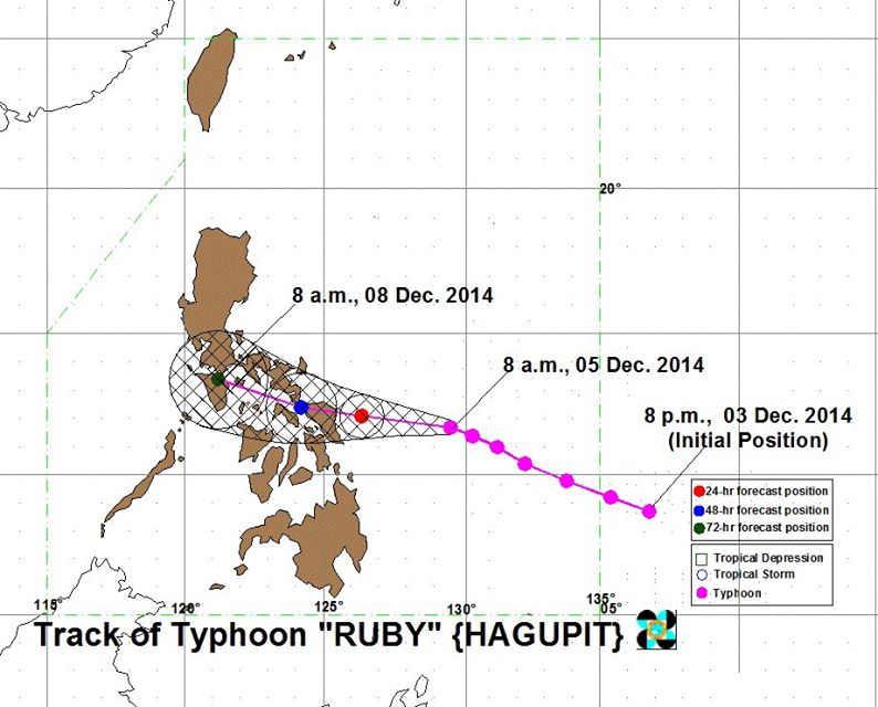
Typhoon Hagupit known as Typhoon Ruby in the Philippines

Weather bulletin no. 19, tropical cyclone warning: Tropical Storm Ruby

issued at 5:00 p.m., December 8, 2014

Expected fourth landfall: Laiya, Batangas 6:00 p.m. today and it will be associated with strong winds, storm surge and moderate to heavy rainfall.

Estimated rainfall amount is from 5 – 15 mm per hour (moderate – heavy) within the 450 km diameter of the tropical storm.

Expected to Exit PAR: Wednesday evening.

Location of eye/center: At 4:00 PM today, the center of Tropical Storm Ruby was estimated based on all available data at 15 km Southeast of Laiya, Batangas (13.6°N, 121.5°E).

Strength: Maximum sustained winds of 85 kph near the center and gustiness of up to 100 kph.

PUBLIC STORM WARNING SIGNAL #2
(Winds of 61-100 kph is expected in at least 24 hrs)

LUZON: Metro Manila, Batangas, Cavite, Bataan, Laguna, Southern Quezon, Marinduque and Northern Oriental Mindoro including Lubang Island.

PUBLIC STORM WARNING SIGNAL #1
(Winds of 30-60 kph is expected in at least 36 hrs)

Zambales, Pampanga, Tarlac, Bulacan, Rizal, Rest of Quezon, Rest of Mindoro Provinces and Romblon.

Weather bulletin no. 18, tropical cyclone warning: Typhoon Ruby,

issued at 11:00 a.m., December 8, 2014

Expected third landfall: Torrijos, Marinduque between 11AM – 12 NN today and it will be associated with strong winds, storm surge and moderate to heavy rainfall.

Estimated rainfall amount is from 5 – 15 mm per hour (moderate – heavy) within the 450 km diameter of the tropical storm.

Location of eye/center: At 10:00 AM today, the center of Tropical Storm Ruby was estimated based on all available data at 20 km East of Torrijos, Marinduque (13.3°N, 122.3E).

Strength: Maximum sustained winds of 105 kph near the center and gustiness of up to 135 kph.

PUBLIC STORM WARNING SIGNAL #3
(Winds of 101-185 kph is expected in at least 18 hrs)

Bataan, Batangas, Cavite, Laguna, Marinduque, Oriental Mindoro, Lubang Island and Southern Quezon.

PUBLIC STORM WARNING SIGNAL #2
(Winds of 61-100 kph is expected in at least 24 hrs)

Pampanga, Rizal, Bulacan, Metro Manila, Rest of Quezon, Occidental Mindoro, Camarines Norte, Camarines Sur, Romblon and Burias Island.

PUBLIC STORM WARNING SIGNAL #1
(Winds of 30-60 kph is expected in at least 36 hrs)

Nueva Ecija, Tarlac, Zambales, Polillo Island, Albay, Sorsogon, Ticao Island, Calamian Group of Island and Masbate, Aklan, Capiz and Semirara Island.

Weather bulletin no. 17, tropical cyclone warning: Typhoon Ruby,

issued at 5:00 a.m., December 8, 2014

Typhoon Ruby has weakened while traversing Sibuyan Sea.

Location of eye/center: at 4:00 a.m., based on all available data, the eye of Typhoon Ruby was 110 km Northwest of Masbate City or at 50 km Northeast of Romblon, Romblon (12.8°N, 122.7°E)

Strength: Maximum sustained winds of 120 kph near the center and gustiness of up to 150 kph

Forecast positions:

24-hour (Tuesday morning:
60 km West Northwest of Calapan City, Oriental Mindoro
48 hour (Wednesday morning):
335 km West of Calapan City, Oriental Mindoro
72 hour (Thursday morning):
575 km West of Coron, Palawan

Public Storm Warning Signal #3
(Winds of 101-185 kph is expected in at least 18 hrs)

LUZON: Burias Island, Marinduque, Romblon, Oriental Mindoro, Occidental Mindoro, Batangas, Laguna, Cavite, Southern Quezon, Lubang Island

Public Storm Warning Signal #2
(Winds of 61-100 kph is expected in at least 24 hrs)

LUZON: Masbate, Ticao Island, Calamian Grp. of Islands, Bulacan, Bataan, Rest of Quezon, Rizal, Sorsogon, Albay, Camarines Sur, Camarines Norte, Metro Manila

VISAYAS: Semirara Island, Biliran, Aklan, Capiz

Public Storm Warning Signal #1
(Winds of 30-60 kph is expected in at least 36 hrs)

LUZON: Sorsogon, Polillo Island, Zambales, Nueva Ecija, Tarlac, Pampanga, Catanduanes, Northern Palawan including Cuyo.

VISAYAS: Northern Samar, Iloilo, Antique, Biliran, Bantayan Island

Expected third landfall: Northern Mindoro between 6 – 8 pm today and it will be associated with strong winds, storm surge and moderate to heavy rainfall.

Estimated rainfall amount is from 5 – 15 mm per hour (moderate – heavy) within the 450 km diameter of the typhoon.

Ruby and the Northeast Monsoon will cause rough to very rough sea conditions over the seaboards of Luzon and Visayas and over the northern seaboard of Mindanao. Fisherfolks and those using small sea craft are advised not to venture out over the said seaboards.

Weather bulletin no. 16, tropical cyclone warning: Typhoon Ruby,

issued at 11:00 p.m., December 7, 2014

Location of eye/center: At 10:00 p.m. December 7, 2014, the eye of Typhoon Ruby was located based on all available data at 70 km Northwest of Masbate City (12.6°N, 123.0°E)

Strength: Maximum sustained winds of 140 kph near the center and gustiness of up to 170 kph.

Forecast Movement: Forecast to move West Northwest at 10 kph.

Forecast positions:

24-hour (Monday evening):
45 km Northwest of Calapan City, Oriental Mindoro
48 hour (Tuesday evening):
290 km West of Calapan City, Oriental Mindoro
72 hour (Wednesday evening):
550 km West of Calapan City, Oriental Mindoro

Public Storm Warning Signal #3
(Winds of 101-185 kph is expected in at least 18 hrs)

LUZON: Masbate, Ticao Island, Burias Island, Marinduque, Romblon, Oriental Mindoro, Occidental Mindoro, Batangas, Laguna, Cavite, Southern Quezon, Lubang Island

Public Storm Warning Signal #2
(Winds of 61-100 kph is expected in at least 24 hrs)

LUZON: Calamian Grp. of Islands, Bulacan, Bataan, Rest of Quezon, Rizal, Sorsogon, Albay, Camarines Sur, Camarines Norte, Metro Manila

VISAYAS: Semirara Island, Biliran, Aklan, Capiz, Bantayan Island

Public Storm Warning Signal #1
(Winds of 30-60 kph is expected in at least 36 hrs)

LUZON: Polillo Island, Zambales, Nueva Ecija, Tarlac, Pampanga, Catanduanes, Northern Palawan including Cuyo.

VISAYAS: Northern Samar, Eastern Samar, Samar, Leyte, Iloilo, Antique, Guimaras, Negros Occidental, Northern Cebu including Cebu City, Camotes Island

Weather bulletin no. 15, tropical cyclone warning: Typhoon Ruby,

issued at 5:00 p.m., December 7, 2014

Strength: Maximum sustained winds of 140 kph near the center and gustiness of up to 170 kph.
Typhoon Ruby has maintained its strength and is now over the vicinity of Aroroy, Masbate.

Forecast Positions:

•24 hour (Monday afternoon): 60 km East of Calapan City, Oriental Mindoro or at 160 km South of Science Garden, Quezon City.
•48 hour (Tuesday afternoon): 170 km Southwest of Science Garden, Quezon City.
•72 hour (Wednesday afternoon): 400 km West of Science Garden, Quezon City.

Public Storm Warning Signal #3

(Winds of 101-185 kph expected in at least 18 hrs)

LUZON: Masbate, Ticao Island, Burias Island, Marinduque, Romblon, and Oriental Mindoro.

Public Storm Warning Signal #2

(Winds of 61-100 kph expected in at least 24 hrs)

LUZON: Sorsogon, Albay, Cavite, Laguna, Batangas, Lubang Island, Quezon, Occidental Mindoro, Camarines Norte and Camarines Sur.
VISAYAS: Northern Samar, Samar, Biliran, Aklan, Capiz, Northern Cebu including Cebu City, Bantayan Island and Camotes Island.

Public Storm Warning Signal #1

(Winds of 30-60 kph expected in at least 36 hrs)

LUZON: Zambales, Bataan, Nueva Ecija, Tarlac, Pampanga, Bulacan, Metro Manila, Rizal, Catanduanes, and Northern Palawan.
VISAYAS: Iloilo, Antique, Guimaras, Negros Occidental, Negros Oriental, Eastern Samar, Leyte, Southern Leyte and Rest of Cebu.

What is a Super-typhoon?

This is a term utilized by the U.S. Joint Typhoon Warning Center for typhoons that reach maximum sustained 1-minute surface winds of at least 240 kph or 150 mph.

This is the equivalent of a strong Saffir-Simpson category 4 or category 5 hurricane in the Atlantic basin or a category 5 severe tropical cyclone in the Australian basin.

Wind Speed Definitions:

Gusts are just a few seconds, for example the maximum speed sustained for about 3 to 5 seconds.
Maximum sustained wind is normally taken over a ONE, TWO or TEN minute period, to get a value for a sustained wind peak.  These reports use the ONE MINUTE system.

Weather bulletin no. 14, tropical cyclone warning: Typhoon Ruby,

issued at 11:00 a.m., December 7, 2014

Public Storm Warning Signal #3

LUZON: Masbate, Ticao Island, Sorsogon, Albay including Burias Island, and Romblon
VISAYAS: Northern Samar and Samar.

Weather bulletin no. 13, tropical cyclone warning: Typhoon Ruby,

issued at 5:00 a.m., December 7, 2014

Public Storm Warning Signal #3

LUZON: Romblon, Catanduanes, Camarines Sur, Albay, Sorsogon and Masbate including Burias and Ticao Island
VISAYAS: Northern Samar, Eastern Samar, Samar, Leyte and Biliran.

Weather bulletin no. 12, tropical cyclone warning: Typhoon Ruby

issued at 11:00 p.m., December 6, 2014

Typhoon Ruby has made landfall over Eastern Samar and is now heading towards Masbate.
• Expected Second landfall: Sunday afternoon in the vicinity of Masbate and it will be associated with strong winds, storm surge (up to 4.5 meters) and heavy to torrential rainfall.
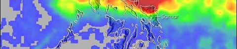
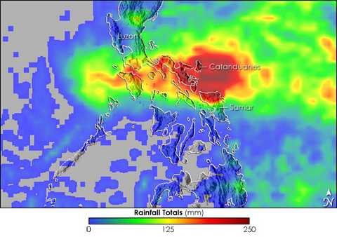
• Estimated rainfall amount is from 10 – >30 mm per hour (heavy – torrential) within the 600 km diameter of the typhoon.
• “RUBY” and the Northeast Monsoon will bring rough to very rough sea conditions over the seaboards of Northern Luzon, eastern seaboard of Central and Southern Luzon, seaboards of Visayas and over northern and eastern seaboards of Mindanao. Fisherfolks and those using small seacraft are advised not to venture out over the said seaboards.

Strength: Maximum sustained winds of 175 kph near the center and gustiness of up to 210 kph.

Public Storm Warning Signal #3
(Winds of 101-185 kph is expected in at least 18 hrs)

LUZON: Romblon, Catanduanes, Camarines Sur, Albay, Sorsogon, and Masbate including Burias and Ticao Island
VISAYAS: Northern Samar, Eastern Samar, Samar, Leyte and Biliran.

Public Storm Warning Signal #2
(Winds of 61-100 kph is expected in at least 24 hrs)

LUZON: Camarines Norte, Southern Quezon, Marinduque, Oriental Mindoro and Occidental Mindoro.
VISAYAS: Northern Antique, Aklan, Semirara Grp. of Islands, Capiz, Northern Iloilo, Northern Cebu including Cebu City, Bantayan and Camotes Island, and Southern Leyte

Public Storm Warning Signal #1
(Winds of 30-60 kph is expected in at least 36 hrs)

LUZON: Pampanga, Bulacan, Rest of Quezon, Rizal, Cavite, Laguna, Batangas, Lubang Island, Calamian Group of Islands, Cuyo and Metro Manila
VISAYAS: Rest of Antique,Rest of Iloilo, Guimaras, Negros Occidental, Negros Oriental, Rest of Cebu and Bohol.
MINDANAO: Surigao del Norte including Siargao Island and Dinagat Province.

Weather bulletin no. 11, tropical cyclone warning: Typhoon Ruby,

issued at 5:00 p.m., December 6, 2014

Strength: Maximum sustained winds of 175 kph near the center and gustiness of up to 210 kph.

Expected landfall: Saturday evening in the vicinity of Dolores, Eastern Samar and it will be associated with strong winds, storm surge (up to 4.5 meters) and heavy-torrential rainfall.

Estimated rainfall amount is from 10 – >30 mm per hour (heavy – torrential) within the 600 km diameter of the typhoon.

Public Storm Warning Signal #3

LUZON: Catanduanes, Albay including Burias Island, Sorsogon, Masbate, and Ticao Island.
VISAYAS: Northern Samar, Eastern Samar, Samar, and Biliran.

Storm Warning Signal #3 Impacts:
• Residents in low-lying and mountainous areas are alerted against flashfloods and landslides. Likewise, those living along the coast are warned on the occurrence of big waves associated with Storm Surge which may reach up to 4.5 meters.
• Heavy damage to agricultural plantation, medium and large trees maybe uprooted
• Considerable damage to structure of light to medium construction, while, majority of nipa and cogon houses unroofed or destroyed
• Severe damage to Billboards & signages
• Evacuation to a safer shelters is highly recommended
• Electrical power distribution and communication services maybe severely disrupted

Public Storm Warning Signal #2

LUZON: Camarines Sur and Romblon.
VISAYAS: Aklan, Capiz, Northern Cebu including Cebu City, Bantayan Island, Leyte and Southern Leyte.

Public Storm Warning Signal #1

LUZON: Southern Quezon, Camarines Norte, Batangas, Marinduque, Oriental Mindoro and Occidental Mindoro.
VISAYAS: Antique, Iloilo, Guimaras, Northern Negros, Rest of Cebu and Bohol.
MINDANAO: Surigao del Norte including Siargao Island and Dinagat Province.

Weather bulletin no. 10, tropical cyclone warning: Typhoon Ruby,

issued at 11:00 a.m., December 6, 2014
Strength: Maximum sustained winds of 185 kph near the center and gustiness of up to 220 kph.

Weather bulletin no. 9, tropical cyclone warning: Typhoon Ruby,

issued at 5:00 a.m., December 6, 2014

Strength: Maximum sustained winds of 195 kph near the center and gustiness of up to 230 kph

Expected landfall: Sunday morning over the Eastern Samar – Northern Samar area and it will be associated with strong winds, storm surge (up to 4.5 meters) and heavy-intense rainfall.

Estimated rainfall amount is from 7.5 – 20 mm per hour (heavy – intense) within the 600 km diameter of the typhoon.

Public Storm Warning Signal #2

LUZON: Catanduanes, Albay, Sorsogon and Masbate including Ticao Island.
VISAYAS: Biliran, Leyte, Southern Leyte, Northern Cebu including Cebu City, Bantayan Island and Camotes Island.
MINDANAO: Dinagat Province

Public Storm Warning Signal #1

LUZON: Camarines Norte, Camarines Sur, Burias Island, Romblon,
Southern Quezon and Marinduque.
VISAYAS: Capiz, Iloilo, Antique, Guimaras, Aklan, Negros Oriental, Negros Occidental, Rest of Cebu, Siquijor and Bohol.
MINDANAO: Surigao del Sur, Surigao del Norte including Siargao Island, Agusan del Norte, Agusan del Sur and Camiguin

Weather bulletin no. 8, tropical cyclone warning: Typhoon Ruby,

issued at 11:00 p.m., December 5, 2014

Strength: Maximum sustained winds of 195 kph near the center and gustiness of up to 230 kph

Weather bulletin no. 7, tropical cyclone warning: Typhoon Ruby,

issued at 5:00 p.m., December 5, 2014

Strength: Maximum sustained winds of 195 kph near the center and gustiness of up to 230 kph

Typhoon Ruby has slightly weakened as it continues to move West Northwest towards the Eastern Samar – Northern Samar area.

Expected landfall: Saturday evening over the Eastern Samar – Northern Samar area and it will be associated with strong winds, storm surge (3-4 meters) and heavy-intense rainfall.

Estimated rainfall amount is from 7.5 – 20 mm per hour (heavy – intense) within the 600 km diameter of the typhoon.

Areas under signal #2

LUZON: Albay, Sorsogon, Ticao Island and Masbate.
VISAYAS: Northern Samar, Eastern Samar, Samar, Biliran, Leyte, Southern Leyte, Northern Cebu including Cebu City, Bantayan Island and Camotes Island.

Areas under signal #1

LUZON: Catanduanes, Camarines Norte, Camarines Sur, Burias Island and Romblon
VISAYAS: Capiz, Iloilo, Antique, Guimaras, Aklan, Negros Oriental, Negros Occidental, Rest of Cebu, Siquijor and Bohol.
MINDANAO: Surigao del Sur, Agusan del Norte, Surigao del Norte, Dinagat Island, Siargao Island, Agusan del Sur and Camiguin Island.

Weather bulletin no. 6, tropical cyclone warning: Typhoon Ruby,

issued at 11:00 a.m., December 5, 2014

Strength: Maximum sustained winds of 215 kph near the center and gustiness of up to 250 kph

Weather bulletin no. 5, tropical cyclone warning: Typhoon Ruby,

issued at 5:00 a.m., December 5, 2014

Strength: Maximum sustained winds of 215 kph near the center and gustiness of up to 250 kph

Weather bulletin no. 4, tropical cyclone warning: Typhoon Ruby,

issued at 11:00 p.m., December 4, 2014

Strength: Maximum sustained winds of 205 kph near the center and gustiness of up to 240 kph

Weather bulletin no. 3, tropical cyclone warning: Typhoon Ruby,

issued at 5:00 p.m., December 4, 2014

Strength: Maximum sustained winds of 205 kph near the center and gustiness of up to 240 kph

Weather bulletin no. 2, tropical cyclone warning: Typhoon Ruby,

issued at 11:00 a.m., December 4, 2014

Strength: Maximum sustained winds of 195 kph near the center and gustiness of up to 230 kph

Weather bulletin no. 1, tropical cyclone warning: Typhoon Ruby,

issued at 11:00 p.m., December 3, 2014

Strength: Maximum sustained winds of 160 kph near the center and gustiness of up to 195 kph

News Reports:

Friday 5th December

As of 2 a.m. EST Friday, JTWC lowered its estimate of Hagupit’s top winds to 145 mph, meaning it is no longer a “super” typhoon.
However, it is still the equivalent of a Category 4 hurricane.
While Hagupit has lost its super-typhoon status, it is still a formidable storm with the potential to cause serious damage.

http://www.usno.navy.mil/JTWC/

Thursday 4th December

The United States Joint Typhoon Warning Center (JTWC) has classified Typhoon Hagupit (Ruby) as a super typhoon.

http://www.philstar.com/headlines/2014/12/04/1398981/ruby-now-super-typhoon-enters-par

Typhoon Ruby Track

Major Typhoons in the Philippines to 2014

The most deadly Storms in the Philippines during the 10 years to 2014

The following SIX Typhoons (tropical cyclones) have each seen more than 1,000 lives lost in the Philippines during the ten years ended in 2014.

2013

Typhoon Yolanda – Typhoon Haiyan: 3rd Nov to 11th Nov 2013: Over 7,300 deaths

2012

Typhoon Pablo – Typhoon Bopha: 25th Nov to 9th Dec 2012: 1,901 deaths

2011

Typhoon Sendong – Typhoon Washi: 13th Dec to 19th Dec 2011: 1,268 deaths

2008

Typhoon  Frank – Typhoon  Fengshen: 17th Jun to 27th  Jun 2008: 1,410 killed (846 from the sinking of the Princess of the Stars)

2006

Typhoon Reming – Typhoon Durian: 24th Nov to 9th Dec 9 2006: 1,399 deaths (mainly due to mudslides from Mt Mayon)

2004

Typhoon Ibiang – Typhoon Winnie: 27th Nov to 30th Nov 2004: 1,593 deaths

References:

Tropical Cyclone – Hurricane – Strong Tropical Typhoon. These terms are used in different areas of the world, but basically mean the same.

Tropical Depressions have a maximum sustained surface winds of less than 39 mph.

Tropical Cyclones have wind speeds of at least 39 mph. They are often referred to as a Tropical Storm, or a Category 1 cyclone in Australia.

Hurricane, Typhoon, Severe Tropical Cyclone, Category 3 Cyclone, Very Severe Cyclonic Storm or Tropical Cyclone, depending on the location and have wind speeds of at least 74 mph.

Typhoons in Puerto Galera

Typhoons, or the threat of them, is something of concern to many people considering a holiday in Puerto Galera, so… what is the real risk ?

The normal typhoon season is between July and October although the worst case was in a December.

1996 – December: The super typhoon Reming, internationally called Typhoon Durian, pounded Puerto Galera and damaged many of the boats at anchor in Muelle Port.  This was the country’s worst typhoon since records have been written, but no deaths in Puerto Galera occurred although many livelyhoods were badly hit.  Over 300 houses were damaged, some with roofs completely blown off, and some of the better built resorts in Sabang and White Beach also needed some immediate repairs.

In the eastern part of the Philippines, mainly Legazpi City and the rest of Albay, including Mount Mayon, where the Typhoon first hit, the death toll exceeded 1,000.
In total, over 2,000 deaths in Asia were reported to have occurred from this Typhoon, but none in this area.

2006: Two two super-typhoons, May and December, damaged the shallow areas around Escarceo Point, one of the popular diving sites.

Other than the two cases above, the normal worst case scenario is that tourists would be forced to stay inside hotel rooms while the storm is on.

In 1574 the Spanish conquerors chose the natural harbour of Puerto Galera (Spanish for Harbour of Galleons) as it provides perfect protection from typhoons and storms. Through the centuries, the Spanish used Puerto Galera as a safe harbor for their galleons. Even today, Puerto Galera normally serves as a safe harbour when a typhoon comes through the central Philippines, except in 1996.

This satellite map from NASA shows the path of Typhoon Durian across the Philippines.
Typhoon Durian from NASA